ASHEVILLE, N.C. (828newsNOW) — Heavy rain will continue across Western North Carolina Saturday night, with forecasters warning that another round of downpours could cause flash flooding and landslides in vulnerable mountain communities.
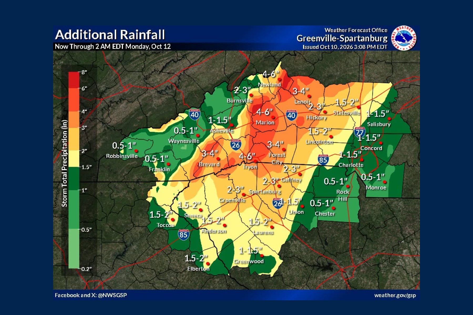
The National Weather Service in Greenville-Spartanburg said Saturday afternoon that some areas along the Blue Ridge Escarpment had already received around 3 inches of rain. Streams and creeks were beginning to rise, and forecasters increased expected rainfall totals slightly along southeast-facing mountain slopes.
Thousands of customers also remained without electricity across the mountains, although Duke Energy’s outage numbers in Buncombe County had improved since earlier in the afternoon.
The remnants of Isaias were centered over Alabama at 3 p.m. Saturday and were expected to move north into the lower Ohio Valley overnight, passing west of the Appalachians.
Forecasters expect the greatest weather threats to begin easing Sunday morning, although rivers could continue rising as runoff moves downstream.
More heavy rain possible overnight
In its 3:44 p.m. forecast discussion, the National Weather Service said rainfall rates generally had not exceeded an inch over three hours during the day.
But forecasters were watching for isolated bands of heavier rain that could produce 1 to 2 inches in as little as an hour Saturday evening or overnight, increasing the risk of flash flooding where the ground has already absorbed significant rainfall.
A flood watch remains in effect until 2 p.m. Sunday for much of Western North Carolina.
Forecasters expect widespread storm rainfall totals of 2 to 4 inches across the watch area, with locally higher amounts along south- and east-facing mountain slopes.
The Weather Service said rainfall projections had increased slightly along the southeast-facing Blue Ridge Escarpment, while amounts remained similar or decreased slightly in some other areas.
Rainfall exceeding 5 inches in 24 hours has been associated with an increased risk of landslides in similar storms, particularly along steep mountain slopes.
Buncombe County identifies areas of concern
Buncombe County emergency officials said in a 3 p.m. update that Black Mountain, the Broad River area, Fairview and Swannanoa face increased risks of heavy rainfall, flash flooding and landslides.
Officials emphasized that flooding can occur anywhere in the county.
The county said widespread catastrophic impacts like those experienced during Hurricane Helene are not anticipated, but localized flooding, isolated landslides and power outages remain possible.
Emergency response teams are prepared and coordinating with local agencies, according to the county.
Residents whose homes or access roads have flooded before, or who live near streams, low-lying areas or steep slopes, are encouraged to consider relocating early while roads remain safe.
All Buncombe County river parks are closed.
Power outages continue across the mountains
Duke Energy’s outage map showed 95 active outages affecting 1,044 customers in Buncombe County at 5 p.m. Saturday.
That was an improvement from the earlier afternoon update, when 105 outages were affecting 2,860 customers.
Elsewhere in Western North Carolina, Duke Energy reported 14 outages affecting 1,101 customers in Jackson County and 31 outages affecting 933 customers in Macon County.
Together, those three counties had 3,078 Duke Energy customers without electricity at 5 p.m.
Earlier Saturday, the Asheville Fire Department said Duke Energy was bringing additional crews from the coast to help restore electricity.
French Broad Electric Membership Corporation also reported approximately 1,000 outages across its service territory shortly before 2 p.m.
The cooperative said strong winds were pushing trees onto power lines in higher elevations, and broken utility poles could delay restoration in some areas.
As of 5 p.m., Duke Energy’s outage map listed estimated restoration times of Sunday morning in Buncombe County and late Sunday night in Jackson and Macon counties. Actual restoration times may vary depending on damage and conditions crews encounter.
French Broad, Pigeon rivers being watched
Flood advisories remain in effect for the French Broad River near Fletcher and the Pigeon River near Canton.
The Weather Service said the French Broad and Pigeon rivers were among those most likely to experience significant rises as runoff from the mountains moves downstream.
The upper French Broad River watershed, generally upstream of Etowah, could receive 4 to 8 inches of rain, with isolated amounts of 8 to 10 inches possible.
In the upper Pigeon River watershed, upstream of Canton, rainfall totals of 4 to 9 inches were forecast, with isolated amounts reaching 10 to 11 inches.
Those projections apply to specific mountain watersheds, not the Asheville area as a whole.
Earlier river forecasts called for the Pigeon River near Canton to rise above its advisory stage Sunday morning. That advisory extends into late Sunday night.
The French Broad River near Fletcher was forecast to crest above its advisory stage early Sunday afternoon. Its advisory remains in effect into Monday afternoon.
At those gauges, the earlier forecasts indicated relatively shallow flooding could develop in low-lying areas near the rivers, including farmland, parks, greenways and some secondary roads.
The latest Weather Service discussion indicated that some rivers, particularly the French Broad and Pigeon, could reach flood stage. However, that does not mean flooding is certain at the specific gauges near Fletcher and Canton.
Residents along the rivers are encouraged to monitor updated forecasts because conditions can change as additional rain falls.
Strongest winds may have passed in some areas
Strong winds caused problems across the mountains earlier Saturday, including a preliminary 67 mph gust reported near Mount Mitchell in Yancey County at 8:10 a.m.
By late afternoon, the National Weather Service said the strongest widespread winds appeared to have peaked across southwestern North Carolina, northeast Georgia and Upstate South Carolina.
Most reporting stations were showing gusts below 30 mph.
Although the strongest winds appeared to have passed in parts of the region, forecasters said gusty conditions could continue Saturday evening, especially in the northern mountains and along the eastern Blue Ridge Escarpment.
A high wind warning for elevations above 3,500 feet and wind advisories for lower elevations remained in effect until 8 a.m. Sunday as of the afternoon forecast.
The Weather Service said it might reconsider some of those alerts Saturday evening if conditions continued improving.
When will conditions improve?
The National Weather Service expects the overall risk of flash flooding, landslides and strong winds to begin diminishing Sunday morning as Isaias moves farther north.
Clouds should gradually lift from west to east beginning late Sunday morning, although some cloud cover could linger throughout the day.
Gusty northwest winds may return to higher elevations Sunday night into Monday, with gusts of 25 to 35 mph possible.
After that, forecasters expect mostly dry weather and a warming trend through the middle of next week.
Even as the weather improves, residents near rivers and streams should continue monitoring water levels because flooding can develop after the heaviest rain has ended.
How to get emergency alerts
Buncombe County residents can sign up for emergency notifications by texting BCReady to 67283.
The county also reminded residents to keep emergency supplies available, avoid flooded roads and stay away from downed power lines.
Power outages should be reported directly to utility providers rather than 911.
Duke Energy customers can text OUT to 57801 or call 1-800-POWERON. French Broad Electric customers can call 1-800-222-6190.
The latest watches and warnings are available from the National Weather Service at weather.gov/gsp.